Hurricane Dorian - Monday Update
Dear San Carlos Owners:
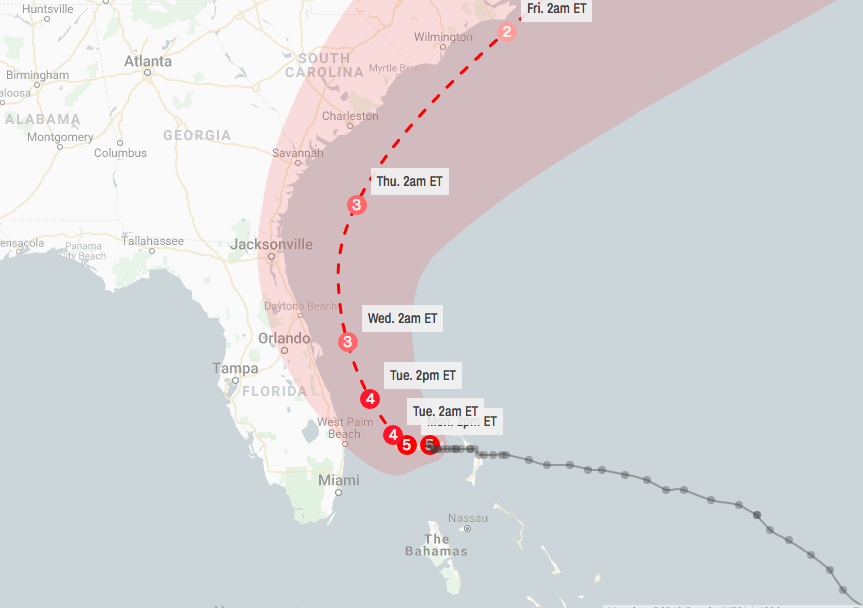
Hurricane Dorian has stalled, continuing its siege on the northwestern Bahamas, but will track dangerously close to a long swath of the East Coast from Florida to Georgia, South Carolina, North Carolina and southeastern Virginia this week. Dorian’s intensity has backed off ever so slightly from yesterday’s peak and is now a strong Category 4, as it has finally undergone an eyewall replacement, common to all intense tropical cyclones during which its intensity diminishes as a new outer eyewall forms, chokes off its former inner eyewall and contracts inward. Despite that, it is still a formidable hurricane, and will remain so over the next several days.
Dorian’s Forecast Timing
Monday: Dorian will still be hammering the northwestern Bahamas as it crawls slowly. Bands of rain and strong winds may affect parts of Florida. Tropical-storm-force winds (39-plus mph) are expected in the tropical storm and hurricane warning areas of eastern Florida, with hurricane-force winds (74-plus mph) possible as soon as late Monday night in the hurricane warning area. How strong the winds will be depends on how close the center of Dorian is to the Florida coast, which is still uncertain at this time. Battering waves, coastal flooding and beach erosion will increase along the southeastern coast of Florida.
Tuesday: Dorian will still be hammering the northwestern Bahamas, but conditions should slowly improve by night. Bands of rain and strong winds will still affect parts of Florida. Hurricane-force winds are expected in the hurricane warning area of eastern Florida. Coastal flooding and beach erosion will spread northward along the Florida coast.
Wednesday: Dorian is expected to move north, then northeastward near the coasts of northeastern Florida, Georgia, and southern South Carolina. The exact track is very uncertain, ranging from a track far enough offshore to keep hurricane-force winds away from land to a landfall anywhere in this zone. Storm-surge flooding, damaging winds and flooding rain are all possible in these areas.
Thursday: Dorian is expected to pass near the coasts of northeast South Carolina and North Carolina. The exact track is very uncertain, ranging from a track far enough offshore to keep hurricane-force winds away from land to a landfall anywhere in this zone. Storm-surge flooding, damaging winds and flooding rain are all possible in these areas. Some impacts from wind and coastal flooding could spread as far north as the Virginia Tidewater and the southern Delmarva Peninsula late.
I will continue to update everyone if anything should change.
Friday-Saturday: Dorian is then expected to race off the Northeast Seaboard but could track close enough to bring rain and some wind to the Virginia Tidewater, Delmarva Peninsula, Nantucket, Martha’s Vineyard and Cape Cod before it heads toward the Canadian Maritimes by the weekend.