The National Hurricane Center update reflects that Hurricane Laura is
currently intensifying over the Gulf of Mexico and expected to become a
major hurricane prior to striking the upper Texas or southwest Louisiana
coasts late Wednesday or early Thursday (presently a Category 1 hurricane).
Significant storm surge and destructive winds will batter the coast and a
threat of flooding rain and strong winds will extend well inland. A
hurricane warning is now in effect from San Luis Pass, Texas, to
Intracoastal City, Louisiana. Laura is predicted to become a major
hurricane – Category 3 or stronger on the Saffir-Simpson Hurricane Wind
Scale – prior to making landfall.
There may still be subtle, yet important changes to the track and intensity
behind Laura’s forecast. Gulf Shores is currently not projected to be in
Laura’s path or a recipient of any significant storm surge. However, any
eastward shift of the track could increase the threat of Laura’s strongest
winds, storm surge, and rain in the Gulf Shores area. Because of this
possibility, all San Carlos Owners and Guests should take necessary
precautions for the possibility of a direct/indirect hurricane strike. At
the very least, assuming Laura remains on the same path, Gulf Shores can
expect increased rainfall/winds over the next few days.
Summary of update:
* Laura strengthened into a hurricane Tuesday morning in the southern
Gulf of Mexico;
* Conditions in the Gulf of Mexico should allow Laura to strengthen
significantly;
* Laura is predicted to become a major hurricane prior to landfall on
the upper Texas or southwest Louisiana coasts.;
* Significant storm surge and damaging winds will affect areas near
where Laura makes landfall;
* Laura is also an inland flood risk as far north as Arkansas or
southern Missouri;
* Isolated tornadoes are also expected from Laura.
In sum, Laura’s track should keep the storm well west of Alabama, but the
National Weather Service in Mobile is continuing to keep a close eye on it.
Alabama coastal areas will face the threat of rip currents, rough surf, and
minor coastal flooding for the next few days. Gulf Shores currently has a
high surf advisory through Wednesday, with 6- to 8-foot breakers possible.
Minor coastal flooding of 1 to 2 feet will also be possible in low-lying
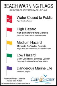
areas in Mobile and Baldwin counties. Owners and Guests are urged to take
note of surf conditions by viewing the flags posted each morning on the San
Carlos flag pole:
If you were wondering what happened with Marco. basically that system
emerged into a non-threat early this morning. Marco made landfall as a
minimal tropical storm with 40 mph winds near the mouth of the Mississippi
River on Monday evening. Marco weakened even more overnight and became a
remnant low on Tuesday morning, and the hurricane center has issued its last
advisory on it.
I will continue to monitor Hurricane Laura and update everyone as more
information becomes available. As mentioned in my previous posts, please
review the following to assure preparedness:
1) If you rent your unit, please contact your management company
to discuss procedure for removing all furniture and items off of your
balcony (especially end units due to the fact that items will need to be
removed even if the system doesn’t reach hurricane status);
2) San Carlos staff is always here to assist with moving your
furniture and balcony items into your unit (cost of $25 and does not include
moving items back out onto the balcony);
3) If this system advances into hurricane status, I will provide
as much notice as possible toward locking the building down, erecting our
hurricane shutter system, raising all elevators, and essentially making
absolutely certain we are adhering to every aspect of our hurricane
preparedness procedure in an effort to protect this building and each of
your units.
Please feel free to call me with any questions or concerns (251.747.4111).
Sincerely,
-Dan