Dear San Carlos Owners & Guests,
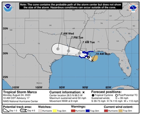
Tropical Storm Marco is currently located approximately 55 miles southeast of the mouth of the Mississippi River and has significantly weakened over the past 24 hours. The storm’s maximum sustained winds are 50 mph, keeping it within tropical storm status and not reaching the status of a hurricane. Marco will continue moving through the northern Gulf of Mexico and will likely maintain tropical storm status as it approaches and makes a glancing landfall in southeastern Louisiana late today or early Tuesday. From there, it will make a west-northwest turn, keeping the center close to the Louisiana and Texas coast through early Wednesday morning.
Strong wind shear will continue to break apart Marco as it drifts along the western Gulf Coast, making it weaken to a tropical depression on Tuesday and then eventually a remnant low pressure system by Wednesday. Marco is expected to bring heavy rain and gusty winds to parts of Alabama today, with coastal areas getting the strongest winds and heaviest rain. Please note, however, that the tropical storm watches and warnings have been canceled for the coast as it pertains to Marco. The National Weather Service in Mobile has projected 3-6 inches of rainfall, closer to the coast, resulting from Marco.
Summary of updates toward Marco:
* Marco will track near the northern Gulf Coast on Monday;
* Marco will continue to weaken because of unfavorable upper-level winds;
* Significant rainfall and strong winds are the expected impacts from Marco.
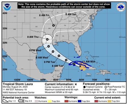
Tropical Storm Marco’s Path:
[TS Marco track 10 a.m. Monday]
Meanwhile, Tropical Storm Laura is currently in the northwestern Caribbean Sea approaching western Cuba. It will move across western Cuba this afternoon before entering the Gulf of Mexico early Tuesday. Laura will likely threaten the U.S. coast late Wednesday into early Thursday as a potentially formidable hurricane.
Summary of updates toward Laura:
* Laura had 60 mph winds as of early this morning;
* Laura is forecast to strengthen and could become a hurricane by Tuesday;
* Once in the Gulf of Mexico, Laura may strengthen into a more significant system.
The Hurricane Center is anticipating issuing a Hurricane watch for the northwest Gulf coast by this evening.
Tropical Storm Laura’s Path:
[TS Laura track 10 am Monday]
I will continue to monitor both systems and update everyone as more information becomes available. As mentioned in my previous posts, please review the following to assure preparedness:
1) If you rent your unit, please contact your management company to discuss procedure for removing all furniture and items off of your balcony (especially end units due to the fact that items will need to be removed even if the system doesn’t reach hurricane status);
2) San Carlos staff is always here to assist with moving your furniture and balcony items into your unit (cost of $25 and does not include moving items back out onto the balcony);
3) If this system advances into hurricane status, I will provide as much notice as possible toward locking the building down, erecting our hurricane shutter system, raising all elevators, and essentially making absolutely certain we are adhering to every aspect of our hurricane preparedness procedure in an effort to protect this building and each of your units.
Please feel free to call me with any questions or concerns (251.747.4111).
Sincerely,
-Dan